Geology of Garvies Point
THE GEOLOGY OF GARVIES POINT must be viewed as a part of the overall geology of Long Island. However, the preserve offers the visitor a place to observe a number of geologic features which, while typical of Long Island, are not found together in such a limited area elsewhere on the island.
The solid bedrock upon which Long Island rests, and which is exposed in nearby New York City and Westchester County, occurs 400 feet below sea level at Garvies Point. About 70 million years ago, during the Cretaceous Period, sand and clay were spread over this bedrock surface in a shallow water coastal environment. The Cretaceous sands and clays are covered by younger deposits nearly everywhere on Long Island, but the shorefront cliffs at Garvies Point provide excellent exposures of these ancient sediments.
Most of Long Island's surface deposits are composed of material left behind when the last continental glacier melted back to the north. There are two basic types of glacial deposits. The material dropped directly from the melting ice is called "till". It is made up of an unsorted mixture of rock debris from the largest boulders to the finest clay. The other type of glacial deposit is "stratified drift" or "outwash". It is composed of well sorted layers of clay, sand and gravel deposited by melt water streams issuing from the ice.
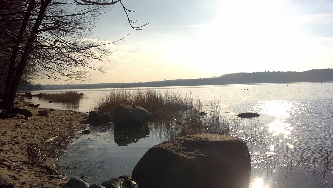
At Garvies Point the glacial deposits are quite thin, consisting of three to five feet of till covering the Cretaceous sand. The most striking evidence left by the ice on the preserve is the assortment of large boulders which were deposited as part of the till layer. The boulders also emphasize the variety of rocks that were plucked up from geologically diverse areas north of Long Island. They were carried along in the ice, as if on a huge conveyor belt, and finally dropped at the base or margin of the glacier.
A few of the boulders bear the scars of their journey. If a boulder is transported for a distance at the bottom of a glacier, one or more surfaces may become flattened and polished or scored by a number of parallel grooves. These are called "glacial polish" and "glacial striations or scratches", and are easily seen on a boulder a few feet from the south corner of the museum.
An important point to remember in connection with the advance of a massive continental ice sheet is that sea level in all parts of the world drops considerably, perhaps as much as 350 feet. This means that when the glacier approached the area that is now Long Island it was then dry land. The exposed land consisted primarily of Cretaceous sands and clays cut by streams and rivers. The advancing ice shoved, folded and gouged the frozen surface deposits, and then covered them with younger glacial outwash and till.
When the continental glaciers melted and the sea rose to its present level the valleys and low lying areas surrounding Long Island were flooded. This event left most of the Cretaceous deposits below sea level. It is only at a few spots on Long Island, such as Garvies Point, that a pre-glacial hill of Cretaceous sediments is exposed above sea level. Several interesting features are found in these layers of sand and clay.
CONCRETIONS
IRON OXIDE CONCRETIONS, LOCALLY KNOWN as "Indian paint pots" can be found in some abundance eroding from the Cretaceous sediments. These curious clay-filled rocks are often found as hollow hemispheres along the beach, having been broken open and the clay washed away by the waves. There are two recognizable origins for these concretions. Most have formed as a result of the precipitation of iron oxide (rust) from the ground water around a lump of clay in a layer of sand. The iron oxide acts as a natural cement, sticking the sand grains together as a crust or shell around the soft clay center. In other cases, irregular rounded lumps of pyrite (iron sulfide) commonly called "fool's gold" are oxidized to form lumps of iron oxide. These are nearly identical in appearance to the clay filled concretions, but are more properly called "pseudomorphs" (one mineral replacing another but retaining the outward form of the first.)
The color of concretions varies depending on the variety of iron oxide of which they are composed. A red-brown or red-purple color indicates hematite (Fe
2O
3) while a dark brown or yellow-brown color shows that the iron oxide is goethite (HFeO
2) and/or limonite (FeO(OH) - nH
2O). All three form upon the oxidation of other iron-containing minerals during the weathering process. In fact, the abundance of iron oxide in the Cretaceous sediments indicates a warmer, moister climate - more conducive to oxidation and chemical weathering than we have currently in this region.
Concretions Page
FOSSILS
WELL PRESERVED IMPRINTS of Cretaceous plants can be found in many of the pieces of red shale and sandstone seen covering the Garvies Point beach. These flat irregular slabs, among the few rocks actually formed on Long Island, were not transported here by the glacier. Thin layers in the Cretaceous sediments have become lithified (turned to stone) by the cementing of the sand, silt or clay particles with iron oxide (usually hematite). During the deposition of the original sediments, leaves and branches and roots of terrestrial (land) plants fell into and were buried in the accumulating layers.
Over the passing millennia, the original plant material decayed and was washed away, but the imprints in the sediment remained. When some layers hardened into sandstones and shale, the fossil imprints were more permanently preserved. The cellular "box work" structure of branches or roots can be seen on the surface of many pieces along the beach. However, the shallow leaf imprints are easily washed away by the water and sand action, so it is necessary to split open the thin slabs to expose fresh surfaces that hide the delicate fossils.
LIGNITE and PYRITE
WITHIN THE CRETACEOUS CLAYS are scattered small lenses of lignite. Lignite is an immature form of coal lying between peat and bituminous (soft) coal in the coal forming process. It is soft and black or brownish black, shows evidence of the plants from which it was formed.
The lignite at Garvies Point has been formed from small pockets of plant remains that were buried during the deposition of the clay. Over millions of years it has been decomposed and squeezed to its present condition. Found within the lignite are small nodules (lumps) of iron sulfide minerals pyrite and perhaps marcasite. The pyrite formed by the combining of sulfur and iron reducing (oxygen poor) environment of the lignite. It is characterized by cube-shaped crystals and brass-yellow color which gives rise to the name "fool's gold". The pyrite on the beach is seen to change in two ways when it is exposed to oxygen rich environments. As already mentioned, it may be replaced by iron oxide, or when exposed to the air it may decompose as a whitish powder iron sulfate.
EROSION
A GOOD LOOK AT THE GARVIES POINT SHORELINE reveals several types of erosion acting on the beach and cliffs. The most striking is the slumping of large sections of the cliff, and the sliding of the slump blocks down the cliff face towards the beach. Slumped sections, such as where trail 2 goes down to the beach, appear as a series of irregular, tree covered steps with their surfaces at different elevations between cliff tops and the beach. This is in contrast to the steep, bare, non-slumped areas that rise directly from the beach to the top of the cliffs.
The slumping is caused by the clay that lies at the base of the cliffs. This clay becomes very slippery when wet, and as a result, whole blocks of ground start to slide downhill over the wet clay. At a few spots the clay can be seen oozing out into piles at the base of the cliffs underneath a slumped area.
Gravity, of course, plays a major role in the sliding of the slump blocks from higher to lower elevations. The movement of material by gravity is even more evident along non-slumped cliffs where talus piles of loose sediment have dropped to the base of the bluffs, as the sand and glacial till is worn away by the wind and rain near the cliff tops. Occasionally, a large boulder can be seen sliding down the cliff face from the till layer. At other spots running water (after rain) has carried sand and gravel down steep gullies and spread the loose material out on the beach as small alluvial fans.
As the cliff sediments crumble, wash and slide down onto the beach, the ever-present waters of Hempstead Harbor pick up the finer sand and clay and carry it along the shoreline and into deeper water. Left behind is a residue of boulders, cobbles and pebbles which are not moved easily by the waves, currents and tides.
TOP