Geology of Long Island
The surface of Long Island is made up of many varied and interesting landforms. Each natural land feature originated through the action of some past or present geologic process. On Long Island these processes can be grouped into three categories - pre-glacial, glacial and post-glacial, depending on whether they occurred before, during or after the advance of a continental glacier onto the Island.
Pre-Glacial
Pre-glacial geologic events in the Long Island include the formation of the ancient (over 400 million year old) metamorphic bedrock that forms
the foundation upon which Long Island rests, and the deposition of sands and clays on this bedrock 70 million years ago, during the late Cretaceous period.
Surface exposures of the bedrock are widespread in Manhattan and the Bronx but are limited on Long Island to small outcrops in northwestern Queens.
The bedrock slopes down to the south and east beneath the rest of Long Island and therefore does not form any significant landforms here.
Resting on the bedrock and extending under nearly all of Long Island is a massive wedge of Cretaceous sediments (sands, clays and gravels). This wedge
is over 2,000 feet thick under Fire Island, but it thins towards the north shore and the western end of the Island to pinch out under Long Island's Sound,
western Queens and Brooklyn. The top surface of the Cretaceous reaches elevations above sea level over an extensive area of northern Nassau and northwestern
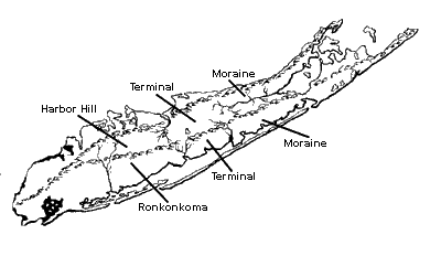
Suffolk counties. The figure below shows the areas above sea level as they might appear if they had not been covered by the younger glacial deposits.
However, because of the glacial cover, exposed Cretaceous sediments are limited to a few scattered localities on present day Long Island. The Cretaceous,
therefore, is an important, but little visible, contributor to Long Island's topography.
Glacial
The geologic event that most greatly affected the land surface of Long Island was the advance of a massive continental glacier into this region
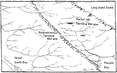
during the Wisconsin stage of the Pleistocene Epoch. The Ronkonkoma and the later Harbor Hill are two sub-stages, or positions, of this ice sheet
which occurred on Long Island. The accumulation of rock debris along these two stationary melting fronts formed two prominent ridges called
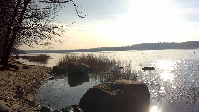
terminal moraines. If you look at the map at the top of the page you can notice where the moraines intersect near Lake Success. East of this point the
ice retreated from the Ronkonkoma to the Harbor Hill position and the two moraines are seen. West of the juncture the Harbor Hill ice moved south,
overriding and destroying the Ronkonkoma terminal moraine. Thus only the Harbor Hill moraine remains to mark the position of the stationary ice
front west of Lake Success. The highest points on Long Island are found along the terminal moraines.
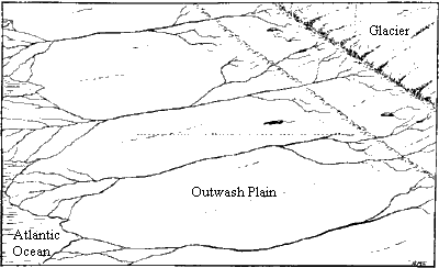
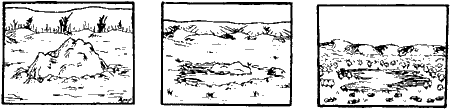
The picture above shows a section of eastern Long Island as it may have appeared when the glacier was melting along the Harbor Hill moraine.
Meltwater streams flowed south to the distant Atlantic Ocean which was over 350 feet below its present level because of the vast amount of water
removed to form the ice sheets. The streams carried sands and silt across the flat coastal plain to form broad glacial outwash plains. The Ronkonkoma
moraine had already been formed and was being cut through by streams coming from the melting ice to the north. For this reason the Ronkonkoma
moraine became more discontinuous than the Harbor Hill moraine.
Read About the Glacial History of Long Island here
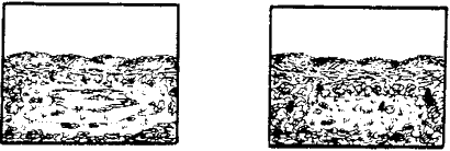
The picture above depicts a section of eastern Long Island after the continental glaciers retreated to the north. Sea level rose with the return of meltwater
to the oceans, to drown hundreds of square miles of outwash plain and to fill Long Island Sound. Shoreline erosion was occurring along the Harbor
Hill terminal moraine and the stream drainage had adjusted to the post-glacial contours of the land.
In addition to the major glacial features (terminal moraines and outwash plains) there are several smaller glacial land features found on Long Island.
Many large boulders, or "glacial erratics", are found on Long Island as part of the moraine deposits. These boulders are most abundant on the terminal
moraines, although many occur in the thin ground moraine layer deposited on the surface north of the terminal moraines as the ice melted. Boulders and large
cobbles generally remain where they dropped from the melting ice because even powerful meltwater streams were unable to move them any great distance.
An exception to this is seen on the North Shore where boulders have dropped to the beach as the sandy cliffs have been eroded by the sea.
Beside their size and beauty, the numerous boulders and cobbles are important because they represent a wide variety of rock types gathered by the
advancing ice as it pushed down from the north. Tracing these rocks to their points of origin gives a good indication of the exact direction of ice flow.
|
Large glacial erratic eroded from Harbor Hill Terminal Moraine on beach near Orient Point. 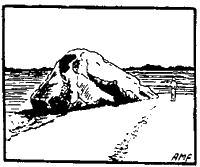
|
"Split rock" - three large glacial erratics that originally were one; on Harbor Hill Terminal Moraine, near Wading River. 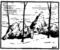
|
This series of pictures shows the melting of a partially buried ice block to form a kettle lake. Small kettle lakes commonly become
filled with sediments and fresh water plant life takes hold in the shallow water to form a marsh as you can see in the figure below on the left.
As the plants decay a spongy mat is formed, often with the disappearance of all open water, and a peat bog is the result shown in the figure below on the right.
As the Wisconsin ice sheet retreated from the Ronkonkoma to the Harbor Hill position, large blocks of ice broke off the face of the glacier. This phenomenon is seen today in the Arctic as icebergs which break off glaciers and float away. On Long Island these huge blocks of ice dropped onto the land surface between the two moraines and were buried in outwash coming from the Harbor Hill glacier. As the ice blocks melted the outwash collapsed leaving depressions in the land called kettle holes. Often these depressions filled with water to become kettle lakes. Scores of these lakes dot the northern half of Long Island. Their sizes are dependant upon the size of the original ice blocks and vary from a three-fourths mile diameter for lake Ronkonkoma to ponds only twenty to thirty feet across.
Post-Glacial
The most noticable post-glacial changes on Long Island have occurred along the many miles of coastline. The action of the waves and currents aided by the wind
have eroded and reshaped the soft glacial sediments to form numerous sandy shoreline features. Less dramatic changes have taken place on the upland surface
caused by the numerous streams and small rivers that slowly cut away the land and transport the sediments to the coast.
SHORELINES
On the south shore, the Ronkonkoma terminal moraine deposits in the vicinity of Montauk Point have been extensively eroded by the powerful waves of the Atlantic Ocean. The south fork of Long Island has been shortened many miles by wave action since the retreat of the glacier. Large amounts of material have been carried westward from the eroding moraine by long shore currents to supply much of the sand for the south shore barrier beaches (Fire Island, Jones Beach, Long Beach, etc.). These long strips of sand are constructed by wave action and long shore currents. The waves act on the shallow sea bottom to form off shore bars. While the westerly drifting currents bring in more sands which extends the bars westward. Fire Island has grown five miles to the west since the lighthouse was built in 1844.
|
Barrier beach, inlet and lagoon. 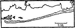
|
Baymouth bar. (Mecox Bay near Bridgehampton) 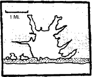
|
The barrier beach is stabilized by wind blown sand which piles into dunes away from the wave zone. Grasses and shrubs grow on the dunes and hold
the sand. The elevation of the dunes and the plants help the beach to resist severe erosion during heavy storms, and prevent it from washing away.
The barrier beaches are cut in several places by inlets that permit tidal waters to sweep in and out of the shallow, marsh-filled lagoons
behind the beaches. Through a natural process of silting and marsh formation these shallow bays, or lagoons, will fill in, thereby joining the barrier beaches with the
mainland of Long Island. This filling process is easily seen in the bays behind Long Beach, where narrow channels separate the many marshy islands.
Waves and currents in Long Island Sound and Peconic and Gardiners Bays have acted in a similar way to those in the open ocean, but on a reduced scale. Numerous sand
features such as spits, tombolos and baymouth bars have formed from the erosion and drifting of material from the shoreline cliffs. Spits are projections of current-drifted
that extend out into open water. Sometimes the end of the spit may curve back towards the land, to form a hook. A spit which reaches across a bay to the etent that it closes,
or nearly closes the mouth is called a baymouth bar. Sand that drifts across open water to connect an island to the mainland, or an island with another island,
is called a tombolo. There are several prominent tombolos on the north shore including Bayville Beach, Asharoken Beach and Truman Beach which connects Orient Point
with the rest of Long Island.
The North Shore of Long Island is also an excellent example of the process of shoreline evolution. Waves and currents continually work to remove projecting points
of land, while indentations and bays fill with sediments. This results in the straightening of an irregular shoreline.
|
Tombolos and spits (Eaton's Neck-Asharoken Beach) 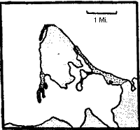
|
Tombolo and large spit 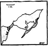
|
Mid-bay bar |
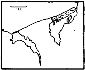
Two baymouth bars forming "winged headland". |
When the rising post-glacial sea flooded Long Island Sound it formed a ragged, deeply embayed coast. The sheltered western end of the present north shore retains much of its original irregular character. Moving eastward, however, the effects of the more active waves and currents in the open end of the sound are seen. The bays become fewer and smaller or even completely marsh-filled, while projecting points of land are reduced to smooth curves in the nearly straight, cliffed shoreline. Eventually the western north shore will also be smoothed by the action of the sea, as will the even more protected irregular shore between the north and south forks.
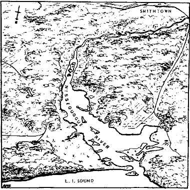
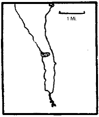
The Nissequogue River estuary. Compare the widened river mouth with the narrow upstream section of the river. The cliffed shoreline and baymouth bar and several marshy islands are also shown.
STREAMS
Stream drainage in Nassau County.
Surface drainage on Long Island is for the most part limited to small streams since the land area is relatively small, and
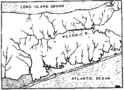
fresh water runoff reaches the sea without gathering into large rivers. The largest river on Long Island is the Peconic River,
which is also the only major east-west draining stream on the island. Other small rivers, such as the Carmans, Connetquot and
Nissequogue appear large near their mouths because these lower portions of their valleys have been flooded and widened by the rising post-glacial
sea. A drowned river valley of this type is called an estuary. Estuarine waters are a brackish mixture of salty sea water and fresh stream water.
The drainage pattern on Long Island is shown in the pictures above and below. In Nassau County the Harbor Hill terminal moraine forms the major
drainage divide. Streams north of this moraine flow north into Long Island Sound, while those south of the ridge flow to
the south into the Atlantic via the stouh shore bays. The Ronkonkoma moraine, although traceable across most of Nassau County, does not form a divide
because today's small streams flow through breaks in the moraine created by the large meltwater rivers of the glacial period.
In Suffolk County the Ronkonkoma ridge becomes more prominent and forms a second drainage divide in this area.
Streams north of the Harbor Hill moraine still flow north to the sound, but those waters which fall south of the Harbor Hill moraine and north
of the Ronkonkoma moraine are diverted eastward into the Peconic Bay. Streams south of the Ronkonkoma moarine drain south to the Atlantic.
In general the streams draining the rugged moraine topography follow short, steep often winding valleys while those draining
across the outwash plains are longer, straighter and flow down gentler slopes at a more leisurely pace.
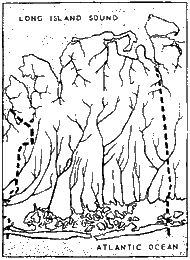
Stream drainage in central Suffolk County.
TOP
Illustrations and layout contributed by Arlene M. Fingerle